Journey Coltsville Then And Now: Two Dogs, Horse, A Family Place In Time
Imagination is rocket fuel. To overlay the past with the present and tell the stories of place and people, struggles and achievement — feed your curiosity.
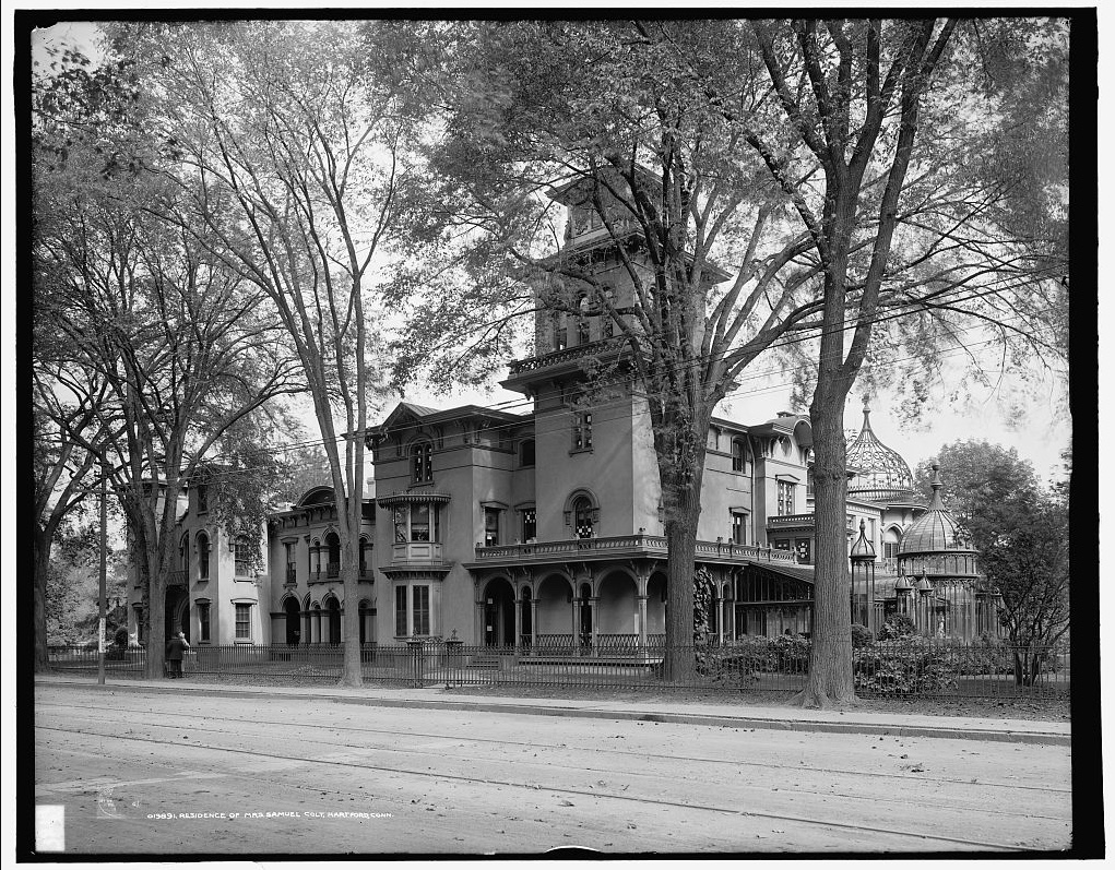
Residence of Mrs. Samuel [Elizabeth H.] Colt, Hartford, Conn., Library of Congress. Note the glass conservatories and details that include the two dog statues.
“…Uffizi dogs, the originals of which are Roman copies of Hellenistic sculptures and stand in the vestibule of the Uffizi Gallery in Florence. The arched windows flanking the front door originally opened onto the loggia behind…”
— Fig. 5 caption in a reprint of The Magazine Antiques March 1976, found by chance at a library sale recently.
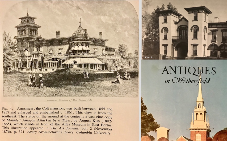
A chance library find (in the “free” bin) yields great information and insight. About Armsmear and the two dogs plus a statue of an Amazon and rearing horse, architectural details.
“Arms manufacturer Samuel Colt and his wife, Elizabeth Hart Jarvis Colt (1826-1905), built Armsmear in 1857. Colt was widowed in 1862. She remained in the residence, carried on the business and became a civic leader, suffragist and patron of the arts. Her many philanthropic endeavors included the Union for Home Work, Hartford Soldier’s Aid Society and Church of the Good Shepherd. On the second floor of Armsmear, she developed an art collection that she later donated to the Wadsworth Atheneum along with the funds to build a wing for them. According to her last wishes, the grounds became Colt Park; the residence was turned into a home for the widows of Episcopalian ministers. Today, Armsmear is an apartment complex for single women.”
— James O'Connell, National Historic Landmark Nomination Form, Coltsville Historic District (2007).
onsite in Hartford.
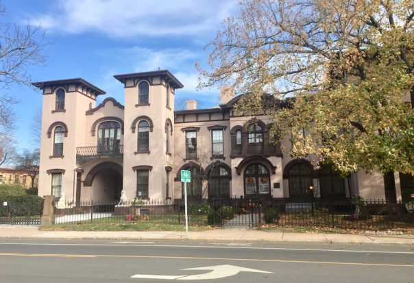
And the former residence of Mrs. Colt, 2018. Note the two dog statues that flank the entrance archway.
National Council on Public History (NCPH) annual meeting in Hartford, ongoing through Saturday, March 30, at the Connecticut Convention Center. Repair Work and includes Coltsville related sessions and tours.
Find the Program at http://bit.ly/ncph2019program. Learn more about the 2019 meeting at http://ncph.org/conference/2019-annual-meeting.
For interesting views and opinions, see the #NCPH (also #NCPH2019) on Twitter. Also, history highlights “Of Bicycles and Archives” post by @CyclinArchivist via Twitter; blog linked here for seeing the Hartford area with new eyes. Also, for those who have not responded to the Hartford 400 survey, here is the link for your input.
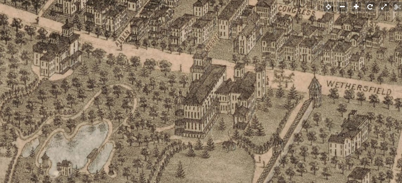
Detail of a Hartford map that depicts the Colt residence (front faces Wethersfield Ave.; now a private residential community) and a portion of what is today Colt Park but without the gardens and water features. Library of Congress Geography and Map Division The city of Hartford, Connecticut. O.H. Bailey & Co., cartographer, 1877.
Note: The Elizabeth Hart Jarvis Colt Collection came to the Wadsworth Atheneum upon the death of Mrs. Colt in 1905. “A time capsule of Victorian Hartford, the collection includes American and European paintings and sculpture, the furnishings and contents of Armsmear—the mansion-house built by Samuel Colt in 1857—and Colt’s personal collection of firearms, edged weapons, and armor from around the world. The latter gathering not only includes prototype weapons from Colt’s firearm company, but also rare and historic pieces given as gifts to Colonel Colt by czars, princes, and sultans.
“Highlights include the wooden model carved by Colt aboard ship in his youth that led him to the design of the perfect revolver, Moorish swords, Italian armor, and scarce examples of Colt’s own products, such as the Walker-Texas holster pistol—perhaps the most storied of all handguns on the Western Frontier.”
Here is a link to the Elizabeth Colt biography in the Connecticut Women's Hall of Fame (inducted 1997).
In the area, coming up: Elizabeth Colt's final resting place and her history, part of a Discover Cedar Hill Highlight Tour, Wednesday, May 15, 10 a.m. when Bob Chudy leads a walking tour. Meet at the flagpole at the end of the entrance drive; fee, $5.
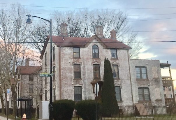
“Colt honored some of the Native Americans who signed the first or second deeds conveyed the land to the Dutch, as follows: Sequassen Street (South Meadow Highway No. 5), was named after “Sounckquasson, Sachem of Suckhaig, alias Hartford,” who conveyed the land around 1636 by the first deed. Streets named for signers of the second deed (1671) by Native Americans to the Town of Hartford: Wawarme Avenue (South Meadow Dyke Road Nos. 5 and 6), named after Warwarme, who was referred to as ‘Wawarme the sister and only heire of Sunckquasson” and referred elsewhere as Sounckquasson, Sachem of Suckhaig, alias Hartford.' Curcombe Street was named after ‘Curry Combe.' Masseek Street named after ‘Massecup.' Weehassat Street (South Meadow Highway No. 4). Referred to in the deed as ‘Wehas a tucks' or ‘Wehassatux, squa.' Vanblock Avenue (South Meadow Highway No. 7) named for the Dutch navigator, Adrian Block, who built the yacht Onrust, which made the first voyage up the Connecticut River under the command of Lieut. Hendrixen when the site of Hartford was discovered. Hendricxen Avenue was named after Cornelius Hendrickson, the lieutenant of the Dutch sloop ‘Onrust.' Note: the spelling of this street appears differently over time. …Huyshope Avenue named after Huys de Hoop (House of Hope), the Dutch Fort. Van Dyke Avenue named after the first commander of the Dutch Fort Good Hope, Guysbert Van Dyke. Vredendale Avenue (South Meadow Highway No. 9) named probably after a plantation called Vrendendale, belonging to a Dutch navigator named DeVries, who visited the Dutch fort in Hartford in 1639. Nepaquash Street, formerly known as the South Meadow Highway No. 6, was named by the Court of Common Council on September 12, 1910 at the suggestion of Charles W. Gross after the Indian Sachem from whom the Dutch purchased the land. (letter in Courant Sept. 1, 1910). This street did not exist in 1877 when the illustrated map was created. However, Nepaquash today runs parallel to Sequassen between Van Block and Vrendendale.”
Standing at the top of the hill at Colt Park near Wethersfield Avenue, the views east and southeast are breathtaking and to the Connecticut River are breathtaking. To see all of the pieces of what was an industrial campus, a family home, sports fields, a village come back to life and add understanding is a worthy effort.
Updated March 27, 2019. The Coltsville Conversation with Scholars (free), Church of the Good Shepherd, 155 Wyllys St., Hartford, happened Wednesday, March 27, 9 a.m. to noon, public discussion and Q&A with scholars from the Coltsville Scholars Roundtable. Updated 3/29/2019. Public plenary session Considering Coltsville, Repairing a Revolving Story, was held at Center Church, 60 Gold St., Hartford. Facilitated by Sarah Pharaon of the International Coalition of Sites of Conscience, with public historians, local activists, and National Park Service representatives for a public conversation about the ongoing planning process for Coltsville National Historical Park, in development just a few blocks from the Connecticut Convention Center. Information linked here; schedule and sessions linked here (PDF).

