Sky’s The Limit: Trails, Parks, Forests, Off Beaten Places: ‘Why Not Try?’
“Embrace what you don’t know, especially in the beginning, because what you don’t know can become your greatest asset. It ensures that you will absolutely be doing things different from everybody else.” – Sara Blakely
The Sky’s the Limit Hiking Challenge is designed to heighten awareness and promote hiking and walking in Connecticut’s State Parks and Forests. CT DEEP State Parks will “ring in spring” on March 19, with the 2020 Sky’s the Limit Hiking Challenge’s list of hikes and walks. This year’s theme: Bridges, footbridges, and boardwalks.

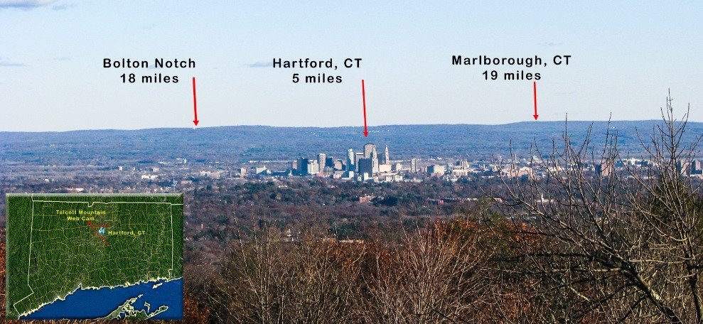
Oh say can you see? Hikes offer panoramic views like this one of Greater Hartford from Talcott Mountain on a clear day, and also, perspective about distances. Image linked to DEEP Facebook page for more information.
But. Trails, parks, walks, resources include the “Supervisors’ and Staff Picks” (2019) and comments on social media can be found via #CTSTL.
Some reminders: Use common sense as weather can change quickly, conditions for roads and trails vary. Let someone know where you are heading by leaving a note and details, time of departure and expected return. Just in case. Reminder: Don't depend on your cellular device as service in some areas is not reliable. Carry paper maps and stay aware of your surroundings. While doing research for a short nature walks book (pre-cell phone), discovered just how easy it is to become disoriented and go off on a side trail (Bear Mountain). The region in rich in places to explore, food to try, people to meet while getting supplies or taking a break after a walk. For those intimidated by a solo walk, start with guided expeditions at a local nature center or learning center. At a loss for where to begin? Ask at your library, start in a park and you will find trails to walk, eventually others who may be willing to share favorite places. Travel even within a state will reveal much about the diversity of terrain, histories, populations. With an open mind, there is deep learning and appreciation for place to gain. Pair with an indoor excursion to Yale Peabody Museum of Natural History in New Haven or Connecticut State Museum of Natural History and Connecticut Archaeology Center in Storrs, then sample a nature center (ask in any community) to uncover connections and others who have walked these trails and land. Especially relevant: Tantaquidgeon Museum (1931), Uncasville, Connecticut. Mashantucket Pequot Museum & Research Center, Mashantucket. The Institute for American Indian Studies Museum & Research Center, Washington, CT.

A personal favorite destination in Redding. An artistic rendering of the winter at what is now Putnam State Park – called Connecticut's Valley Forge. Go for a self-guided walk, the history here is fascinating, and the natural setting beautiful. Connected to the park's site for details.
Now back to finding more inspiration – people in business, entrepreneurs, places, events, life. Get outdoors and leave the digital world behind for awhile to shake loose ideas and solutions. People have many chapters in their lives, serve multiple roles – and some re-invent themselves. Look for more reports on those who decide to act to achieve a goal and also to aim high, whatever their field of expertise.
“Whose story isn't being heard and what are you going to do about it?”
– the late great Gwen Ifill, co-anchor of ‘PBS NewsHour
“All of us are more than one thing.”
– Lin-Manuel Miranda, Hamilton
Some practical tips for outdoor explorations from the DEEP:
Dress for the weather. It is best to dress in layers so as you warm up hiking you can remove outer layers.
Bring water, a whistle, sunblock, map and insect repellant.
Hunting is allowed in most state forests and some state parks so check out the CT Hunting and Trapping Guide and don’t forget to wear orange during hunting season. Also, bring a whistle and make noise so hunters know you are in the area.
Be Bear Aware and do make your presence known by making noise while hiking. Hike in groups. If you see a bear, make enough noise and wave your arms so the bear is aware of your presence.
Remember to protect yourself from Lyme disease and other tick-borne diseases and do a tick check of all those on your outing. Ask your veterinarian for advice on effective tick and flea preventatives for your canine companions.
Dogs must be on leashes for their safety, the safety of wildlife and fellow hikers.
Don’t forget to bring a map and know what the trail blazes mean (don’t think just because there is a wide open trail that is the correct way to go, there might be a spur trail that is not as obvious.)
Be aware of your surroundings and check out options. There might be a trail that takes you around a steep area, consult your map.
Remember to check www.ct.gov/deep/StateParks to confirm the park is open and plan your trip accordingly.
Here are the previous year's Sky’s the Limit locations to explore year round until the new challenge is announced:
Mohawk State Forest, Cornwall/Goshen
Trail Name: Blue Trail
Map: Mohawk State Forest Trail Map
Degree of difficulty: Various, Depending on where you pick up the blue trail
Approximate length: Various
Kettletown State Park, Southbury
Trail name: Miller Trail
Map: Kettletown State Park Trail Map
Parking area: Beach area or road
Degree of difficulty: Moderate
Approximate length: 1.5 miles
Rocky Neck State Park, East Lyme
Trail name: Red Trail to Blue Trail to Yellow Trail (Tony’s Nose Overlook)
Map: Rocky Neck State Park Trail Map
Parking area: Lot on north side of Beach Access Road, the second entrance to the large parking lot on the right
Degree of difficulty: Easy
Approximate length: 2 miles
Note: Nearby, The Book Barn in Niantic. Boardwalk.
Barn Island Wildlife Management Area, Stonington
Trail name: Unnamed
Map: Barn Island Trail Map, Image of Display Area Map
Parking area: Roadside, north of Barn Island Boat Launch, enter at second kiosk on Palmer Neck Road.
Photo locations: Sarah Ann Martin Stone Monument (41º20’593”N, 71º52’238”W) & Impoundment #2
Degree of difficulty: Easy
Approximate length: 3 miles
James L. Goodwin State Forest, Hampton
Trail name: Blue/Yellow to Blue/White to Red and back
Map: James L. Goodwin State Forest Trail Map
Parking area: Conservation Center, 23 Potter Road Hampton
Degree of difficulty: Moderate
Approximate length: 3 miles
Pachaug State Forest — Green Falls Area, Voluntown
Trail Name: Blue/Orange
Map: Pachaug State Forest Trail Map
Parking area: Off season, forest road; seasonally, parking Lot near beach
Degree of difficulty: Moderate
Approximate length: depends on the season, approximately 5 miles in the off season, 3 miles trail only
Please note: The forest road (Green Falls Road) is gated in the off season and opens based on mud season. You may need to hike the road in to reach the trail head.
Salt Rock State Campground, Sprague
Trail name: Old Rail Line Footpath
Map: Salt Rock Trail Map
Parking area: Fishing lots at Salt Rock Campground, behind pool
Degree of difficulty: Easy
Approximate length: 2 miles
Mount Tom State Park, Litchfield
Trail name: Yellow Trail (Tower Trail)
Map: Mount Tom State Park Trail Map
Parking area: Beach lot
Degree of difficulty: Moderate
Approximate Length: 1.2 miles
Harkness Memorial State Park, Waterford
Trail name: Paths around the park
Map: Harkness Memorial State Park Trail Map
Parking area: Main Lot off Great Neck Road
Degree of difficulty: Easy
Approximate length: 1 mile
Things to do in the area: Seaside State Park, on Seaside Drive, is just down the street and is a great spot for a picnic
Wadsworth Falls State Park, Middletown
Trail name: Orange and small amount of Blue to access Little Falls
Map: Wadsworth Falls State Park Trail Map
Parking area: Main Lot near beach
Degree of difficulty: Moderate
Approximate length: 3 miles
American Legion and Peoples State Forest, Barkhamsted
Trail name: Elliott Bronson to Walt Landgraf (Red Trails)
Map: American Legion and Peoples State Forest Trail Map
Parking area: Lot near Matthies Grove
Degree of difficulty: Moderate
Approximate length: 3.2 miles
Macedonia Brook State Park, Kent
Trail name: White to Blue and Return Blue
Map: Macedonia Brook State Park Trail Map
Parking area: By Pavillion
Degree of difficulty: Difficult, not suitable for pets or young children
Approximate length: 2 miles
Dennis Hill State Park, Norfolk
Trail name: Gazebo Loop Trail (Yellow)
Map: Dennis Hill Trail Map
Parking area: At entrance
Degree of difficulty: Easy
Approximate length: 1.3 miles
Horse Guard State Park, Avon
Trail name: White Trail
Map: Horse Guard Scenic Reserve Trail Map
Parking area: At entrance
Photo locations: Shield sign and scenic view
Degree of difficulty: Moderate

